Northeast Stormwater Management Initiative
The MWMO, the City of Minneapolis, and the Minneapolis Park and Recreation Board launched a joint effort to address flooding and water quality issues in Northeast Minneapolis.

Project Details
City: Minneapolis
Type: Capital Improvement Project
Status: Completed
Timeline: 2016–2018
Partners: City of Minneapolis; Minneapolis Park and Recreation Board
Contractors: Applied Ecological Services; SRF Consulting
Nancy Stowe
Projects and Outreach Director
612-746-4978
Email Nancy Stowe
View Bio
Project Background
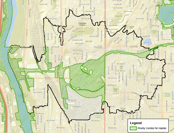
The 1NE Watershed drains 2,150-acres of northeast Minneapolis and southern Columbia Heights into the Mississippi River. The northern and eastern portions of the watershed drain toward, and through, Columbia Park and Columbia Golf Course. From there, the stormwater flows west, in a large pipe, toward the Mississippi River. A low spot on the landscape, Columbia Golf Course once contained historic Lake Sandy and remains a natural spot for water to accumulate.
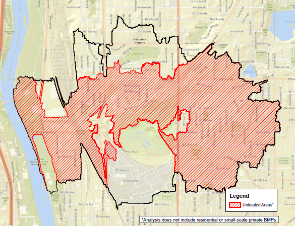
The MWMO has been monitoring the amount and quality of stormwater runoff from the 1NE Watershed since 2006. The watershed contains a mixture of residential, commercial, and industrial development, with a large park, golf course, and railyard lying in its center. Stormwater management challenges within the 1NE Watershed include pockets of localized flooding within residential and industrial areas, large areas of the landscape without stormwater quality treatment, and a golf course and park with significant flooding issues. The 1NE Watershed also provides opportunity for significant ecological improvement, with large swaths of existing, degraded habitat and the presence of historic waterbodies that allow for some level of restoration.
The completion of detailed stormwater models and installation of two additional monitoring locations in the 1NE Watershed in 2015 provided the MWMO significant tools for use in planning and prioritizing improvements within the area.
These considerations, along with City of Minneapolis street projects (providing easier access to the underlying infrastructure) and Minneapolis Park and Recreation Board (MPRB) planning efforts made the 1NE Watershed a priority location for MWMO capital project planning and provided a unique opportunity to fold project outcomes into the capital project planning of our partners.
Project Planning and Implementation
In 2016, the MWMO approached the city and MPRB and asked them to partner on this effort. The first task was to clearly define each partner’s goals (in terms of watershed management) for the area, noting where those goals overlapped and where they diverged. The partners agreed that overlapping themes included increased flood resiliency, reduced pollutant loading to the Mississippi River, and improved ecological function.
The first phase of planning started in 2017, when the MWMO hired SRF Consulting and Applied Ecological Services to assist in developing and vetting stormwater management and ecological improvement scenarios for the area.
Work performed under this effort focused on solutions that would reduce flooding impacts, improve water quality, and that could be constructed by 2022. Strategies to improve ecological function were layered into the solutions developed as part of this effort.
Document – Partner Goals and Consultant Role (PDF, 0.7 MB, 1 page)
The project team worked through various potential projects in the watershed, exploring the likelihood of each to be implemented and quantifying their benefits and costs. The southern portion of the focus area is the site of historic Lake Sandy and other wetland features. This area has a high groundwater table and the potential for significant groundwater-surface water interactions. Given the lack of information on this area’s groundwater, the project team focused on design solutions in the northern half of the study area. Therefore, the project partners agreed to focus planning efforts on the northern and eastern portions of the watershed and areas upstream of Columbia Park and Golf Course, given the large amount of flooding that happens in those areas. It was determined that solutions for the southern portion of the watershed would be addressed under a future study, once additional data is gathered.
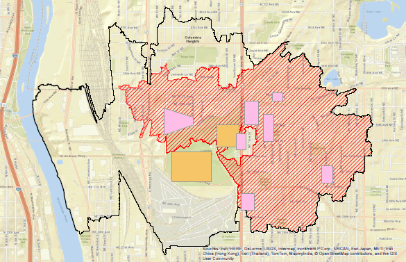
Phase one of the 1NE Watershed Stormwater Management Planning and Preliminary Design study was completed in the summer of 2018. Results of this effort included the identification of broad opportunities for improvements across the 1NE Watershed. Conceptual designs were developed for those projects that were shown to result in significant improvements and advanced the stated goals of the project partners. Projects include modifications to the city’s stormwater infrastructure in the north-central and northeastern parts of the watershed, the addition of regional green stormwater infrastructure in Columbia Park and Columbia Golf Course, and the integration of additional projects within the northern and eastern half of the watershed.
Document – Preliminary Design Projects (PDF, 13 MB, 1 page)
Document – Project Restoration Zones (PDF, 1.6 MB, 1 page)
Document – Future Restoration Opportunities (PDF, 1.9 MB, 1 page)
To date, three of these projects have been prioritized and are either in progress or completed. The Northern Columbia Green Infrastructure project includes an enlarged wet pond and two stormwater basins, associated storm sewer improvements, and ecological restoration in the northern portion of Columbia Golf Course and Columbia Park. There are also nearby pretreatment projects to help ensure the long-term functionality of the wet pond and basins at the golf course and park. The Hoyer Heights Tree Trenches project created additional green stormwater infrastructure as part of street reconstruction project in the area. In both cases, the projects will capture and treat stormwater from areas that are currently untreated.
The Northern Columbia Green Infrastructure will provide treatment to an 813-acre area (75 percent of which currently receives no stormwater treatment) and has the potential to remove up to 170 pounds of total phosphorus and 37 tons of sediment annually. The improvements will also help mitigate flooding. While the Hoyer Heights Tree Trenches will capture and treat stormwater runoff from a smaller area, they will treat runoff from some of our dirtiest urban sources — streets and sidewalks.
Projects that were not able to be implemented within the priority time frame (completion by 2022), were folded into each partner’s capital project planning. The Minneapolis Park and Recreation Board’s East of the River Park Master Plan includes many of these concepts. The City of Minneapolis and MWMO are considering the opportunities as part of their planning processes.
Other Ongoing Work
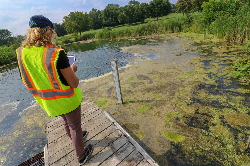
To inform the next phase of project planning for the southern portion of the 1NE Watershed (Phase 2), the area was outfitted in 2018 with piezometers to track groundwater levels and staff gauges to track pond elevations. MWMO and MPRB staff continue to monitor groundwater and surface water elevations within the golf course, in addition to the monitoring that MWMO was already doing in the area.
Subscribe to Updates
Join our project email list to receive periodic updates on projects, meetings and events related to the Northeast Stormwater Management Initiative.
Latest Documents
- Updated Columbia Golf Course and Columbia Park Landscape Design – January 2020 (PDF, 0.7 MB, 1 page) — Posted February 6, 2020
- Hoyer Heights Tree Trenches Graphic — City of Minneapolis (PDF, 2 MB, 1 page) — Posted July 9, 2019
- City of Minneapolis Flood Mitigation Graphic — City of Minneapolis (PDF, 2.7 MB, 1 page) — Posted July 9, 2019
- Ward 1 Current Stormwater Improvement Project — City of Minneapolis (PDF, 0.6 MB, 1 page) — Posted July 9, 2019
- Slides from June 12, 2019, Ward 1 Stormwater Forum (PDF, 2.8 MB, 12 pages) — Posted June 13, 2019