Chesapeake Mapping Initiative
Through the African American Cultural Heritage Action Fund, the National Trust for Historic Preservation is undertaking a long-term initiative, “Documenting Chesapeake Watershed Sites and Landscapes Important to African Americans,” or the Chesapeake Mapping Initiative. This effort is a collaboration between the National Trust; the National Park Service Chesapeake Bay; the states of Maryland, Pennsylvania, and Virginia; and the Chesapeake Conservation Partnership, working together to identify and map sites and landscapes significant to African American history in the watershed.
The Chesapeake Mapping Initiative is intended to ensure that places important to African Americans are better represented in historic preservation and land conservation priorities in the Chesapeake Bay region, and ultimately that more of these places are recognized and protected. It will also lay the groundwork for future mapping efforts for African American historic places by assessing the effectiveness of different project approaches.
As home to some of America’s first colonies, the Chesapeake Bay watershed region has significant meaning to African American history. Many major tobacco plantations were located there, as were many stops on the Underground Railroad. It was the place where Harriet Tubman and both Frederick Douglass and his first wife were enslaved. It includes many battlegrounds of the Civil War, as well as places of notable activism in the 1960s Civil Rights Movement. Generations of Black Americans have made their living from the waters of the Bay and have also used special places along the Bay and throughout the region for recreation. But many of the places that hold the stories of African American life in the watershed are still under-recognized and undocumented by historic preservationists.

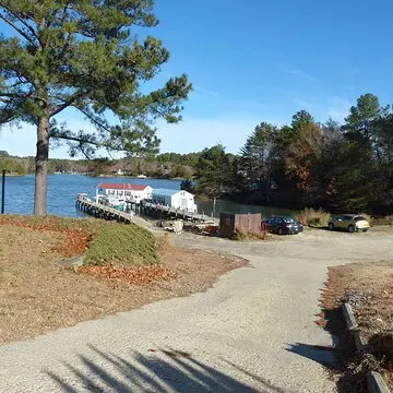
photo by: Commonwealth Preservation Group
Morris-Fisher Stack in Reedville, Virginia
In its first phase of work, the multi-state partnership behind the Chesapeake Mapping Initiative is undertaking three unique pilot projects in watershed areas of Maryland, Virginia, and Pennsylvania. Each pilot project includes outreach to local communities to share information and collect feedback. The work is also guided by an outside advisory committee of professionals dedicated to preserving African American history.
Virginia
In Virginia, work focuses on the identification of historic resources associated with Black watermen culture in Virginia’s coastal communities. The project, which kicked off in 2021, will result in a Multiple Property Document, a National Park Service form used to document historic properties with common themes and histories. The creation of the Multiple Property Document will streamline the nomination of Black watermen-related individual sites or historic districts to the National Register of Historic Places.
More information and updates on this project are available through the website of the Virginia Department of Historic Resources. The public is also invited to share information about historic places with consultant Commonwealth Preservation Group there.
Pennsylvania
The Pennsylvania State Historic Preservation Office’s Baseline Survey Effort 2020-2024 kicked off in 2020 with a particular focus on identifying African American churches and cemeteries. A complimentary crowdsourcing effort that began in 2022 asks communities in south-central Pennsylvania to share their knowledge of places that are connected to African American history in select counties, including churches and cemeteries but not limited to those places. The counties include Adams, Cumberland, Dauphin, Franklin, Fulton, Lancaster, Lebanon, Perry, and York.
Maryland
The pilot project in Maryland began in 2021. Local historians are analyzing the existing records of the Maryland Historical Trust for areas where African American historical connections are missing. Looking at records in the watershed counties of Kent, Calvert, and Somerset, they are using their knowledge of area history to identify places where African American history has been left out and recommending where surveying and research can help correct those omissions.
The Chesapeake Mapping Initiative Phase 1 has been financed in part with State Funds from the Maryland Heritage Areas Authority, an instrumentality of the State of Maryland. However, the contents and opinions do not necessarily reflect the views or policies of the Maryland Heritage Areas Authority.
Additional funding support is provided by the National Park Service Chesapeake Bay Gateways Program and by the Environmental Stewardship Fund of the Pennsylvania Department of Conservation and Natural Resources.
Share your stories from Route 66! Whether a quirky roadside attraction, a treasured business, or a piece of family history, we are looking for your stories from this iconic highway.
Share Your Story