
Boulder Area Trails
3.6star
21 reviews
5K+
Downloads

Everyone
info


About this app
Boulder Area Trails is the OFFICIAL trails app for trails in and around Boulder and Broomfield counties.
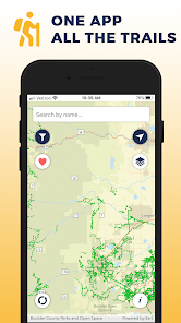
** ONE APP FOR ALL THE TRAILS **
Provides a single source for all designated public recreation trails and trailheads in and around Boulder and Broomfield counties.
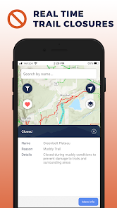
** REAL TIME TRAIL CLOSURES **
Trails closures are posted as soon as they are announced by each participating agency.
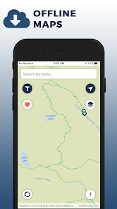
** OFFLINE MAPS **
The app will continue to work even when there is no cellular service. Please note that trail closures will not be shown while offline unless the app was initially opened while connected.
** SET FAVORITES **
Select your favorite trails and trailheads for easy access.
** PARTICIPATING AGENCIES **
- Boulder County
- City and County of Broomfield
- City of Boulder
- City of Lafayette
- City of Longmont
- City of Louisville
- Rocky Mountain National Park
- Town of Erie
- Town of Lyons
- Town of Nederland
- Town of Superior
- US Forest Service
** DISCLAIMER **
The information contained in the Boulder Area Trails Mobile Application is for general information purposes only. The Boulder Area Trails Project makes no warranties regarding the accuracy, completeness, reliability, or suitability of this map. The Boulder Area Trails Project disclaims any liability associated with the use or misuse of this application. In accessing and/or relying on this map, the user fully assumes any and all risk associated with the information contained therein.
** ONE APP FOR ALL THE TRAILS **
Provides a single source for all designated public recreation trails and trailheads in and around Boulder and Broomfield counties.
** REAL TIME TRAIL CLOSURES **
Trails closures are posted as soon as they are announced by each participating agency.
** OFFLINE MAPS **
The app will continue to work even when there is no cellular service. Please note that trail closures will not be shown while offline unless the app was initially opened while connected.
** SET FAVORITES **
Select your favorite trails and trailheads for easy access.
** PARTICIPATING AGENCIES **
- Boulder County
- City and County of Broomfield
- City of Boulder
- City of Lafayette
- City of Longmont
- City of Louisville
- Rocky Mountain National Park
- Town of Erie
- Town of Lyons
- Town of Nederland
- Town of Superior
- US Forest Service
** DISCLAIMER **
The information contained in the Boulder Area Trails Mobile Application is for general information purposes only. The Boulder Area Trails Project makes no warranties regarding the accuracy, completeness, reliability, or suitability of this map. The Boulder Area Trails Project disclaims any liability associated with the use or misuse of this application. In accessing and/or relying on this map, the user fully assumes any and all risk associated with the information contained therein.
Updated on
Safety starts with understanding how developers collect and share your data. Data privacy and security practices may vary based on your use, region, and age. The developer provided this information and may update it over time.

No data shared with third parties
Learn more about how developers declare sharing

No data collected
Learn more about how developers declare collection
Ratings and reviews
3.6
21 reviews

A Google user
- Flag inappropriate
January 10, 2020
Love the unification of data between the groups. This is a great achievement of collaboration. A couple of suggestions; the filtered trail color of pink is too close to red to distinguish a difference. Allowing for trail conditions (snow packed, muddy, dry etc.) would really help visitors plan where to go. Allow this data to be used by other apps. Thank you!
3 people found this review helpful
Boulder County
January 13, 2020
Thanks for your feedback. We've forwarded your suggestions to our developers.

Karl Schroll
- Flag inappropriate
October 23, 2023
Nice to have all area trails in one place. Would be a lot more helpful if we could filter for trails that allow e-bikes.

Richard Shelquist
- Flag inappropriate
- Show review history
June 18, 2021
Pure rubbish now. As of May and June 2021 this dreadful app takes several minutes to initialize with current data. In late 2020 this was an excellent map source for Boulder County hiking, but now COTREX is the app to use.
1 person found this review helpful
What's new
A legend has been added on the info page.
App support
phone
Phone number
+13036786200


