

Abstract
Runoff from snowmelt is regarded as a vital water source for people and ecosystems throughout the Northern Hemisphere (NH). Numerous studies point to the threat global warming poses to the timing and magnitude of snow accumulation and melt. But analyses focused on snow supply do not show where changes to snowmelt runoff are likely to present the most pressing adaptation challenges, given sub-annual patterns of human water consumption and water availability from rainfall. We identify the NH basins where present spring and summer snowmelt has the greatest potential to supply the human water demand that would otherwise be unmet by instantaneous rainfall runoff. Using a multi-model ensemble of climate change projections, we find that these basins—which together have a present population of ∼2 billion people—are exposed to a 67% risk of decreased snow supply this coming century. Further, in the multi-model mean, 68 basins (with a present population of >300 million people) transition from having sufficient rainfall runoff to meet all present human water demand to having insufficient rainfall runoff. However, internal climate variability creates irreducible uncertainty in the projected future trends in snow resource potential, with about 90% of snow-sensitive basins showing potential for either increases or decreases over the near-term decades. Our results emphasize the importance of snow for fulfilling human water demand in many NH basins, and highlight the need to account for the full range of internal climate variability in developing robust climate risk management decisions.
Export citation and abstract BibTeX RIS
Introduction
The accumulation of snow is a vital source of water for natural systems and humans (Barnett et al 2005, Westerling et al 2006, Viviroli et al 2007, Kurz et al 2008, Rood et al 2008, Pierson et al 2013). For humans, snow is a crucial natural reservoir (Barnett et al 2005), providing both flood control and water storage by capturing water in solid form in cold months and releasing it in warm months, concurrent with higher agricultural and evapotranspirative demands (Hayhoe et al 2004, Viviroli et al 2007, Barnett et al 2008). Snow can also serve as a sentinel system, providing a benchmark by which the advance of global warming can be measured (Barnett et al 2008, Renard et al 2008).
Yet analyses reveal that the relationship between snow and warming is more complex than monotonic declines, particularly given that trend detection in mountainous regions is challenging (Brown and Mote 2009, Viviroli et al 2011). In the Western US, for example, increases in freezing elevations (Ashfaq et al 2013), decreases in snowfall-to-rainfall ratios (Knowles et al 2006), earlier snowmelt runoff (Rauscher et al 2008), and decreases in snowfall (Pederson et al 2013), have been observed together with long-term increases in snow accumulation (Howat and Tulaczyk 2005, Mote 2006, Kapnick and Hall 2010). Further, despite projected snow declines by the end of the century (Diffenbaugh et al 2012), the magnitude of internal climate variability suggests that some Northern Hemisphere (NH) regions may experience increases in both mean (Mankin and Diffenbaugh 2015) and extreme (O'Gorman 2014) snowfall for at least the next half century or more, complicating decisions around new water infrastructure or flood management. The implications of a varied snow response for humans and ecosystems will therefore be a function of both the undetermined mix of human-induced climate change and natural climate variability, and the present importance of snow in basin-scale hydrology.
While a number of studies demonstrate that snow supply is vital and likely to decline by mid-century (Barnett et al 2005, Rauscher et al 2008, Diffenbaugh et al 2012, Ashfaq et al 2013, Mankin and Diffenbaugh 2015), assessments of snow as a source of water supply are largely inferred from supply-side measures such as the ratio of total annual snowfall to runoff (Barnett et al 2005), or the fraction of annual streamflow pulsed in the warm season (Stewart et al 2004). Analyses of present snow supply are helpful for identifying the spatial pattern of snow's importance in the overall hydrological cycle (Barnett et al 2005, 2008, Viviroli et al 2007). However, global warming will not influence the supply of snow or the timing or magnitude of snowmelt runoff equally for all basins (Rauscher et al 2008, Adam et al 2009, Brown and Mote 2009, Viviroli et al 2011, Ashfaq et al 2013). Because we do not know snow's relative importance to each region's water supply portfolio, we also do not know the differential risks this heterogeneous response presents to regional water availability in snow-dominated regions.
Human water demand, which is shaped by both basin-scale hydroclimate and the water-demanding activities of people, is supplied by groundwater and surface and subsurface runoff from both rainfall and snowmelt. Given the NH distributions of human water demand, where does snowmelt runoff have the potential to be critical for water supply? Here we present a quantification of the potential for observed and projected snowmelt runoff to fulfill NH spring and summer human water demand. In calculating this 'snow resource potential,' we reconcile the timing and magnitude of each basin's unique sub-annual patterns of snowmelt and rainfall runoff, as well as 'human blue water demand' (surface and groundwater consumption, (Hoekstra et al 2012)). We focus explicitly on human demand, noting that ecosystems also place important and varied demands on snow accumulation and melt (Westerling et al 2006, Rood et al 2008, Pierson et al 2013, Tague and Peng 2013), and are also highly exposed to changes in snow hydrology (Westerling et al 2006, Kurz et al 2008, Rood et al 2008, Pierson et al 2013).
Methods
We perform our analysis at the basin scale. We focus on identifying those basins likely to be most sensitive to changes in snowmelt runoff, given both the magnitude of human blue water demand (hereafter 'demand'), and the potential for snow to supply the fraction of demand that would otherwise be unfulfilled by instantaneous rainfall runoff. We partition mean basin-scale total runoff (surface and subsurface) into contributions from snowmelt and rainfall (supplementary material), and remove the amount of monthly demand that could be fulfilled by rainfall runoff, as discussed below. The remaining demand is 'unmet', and needs to be supplied by alternative sources, such as from groundwater, surface reservoirs, and/or snowmelt. We then calculate the percentage of cumulative spring and summer unmet demand that could be supplied by cumulative spring and summer snowmelt runoff, which we call the 'snow resource potential'. This snow resource potential will exceed 100% if snowmelt runoff exceeds unmet demand. This partitioning separates those basins where spring and summer rains are theoretically sufficient for human needs, versus those where snow contributions could play a critical role in supplying water in both the present and future climates.
We calculate monthly snowmelt runoff (mm) at the grid-point scale. We use the human blue water footprint (Hoekstra and Mekonnen 2012) to estimate NH basin-scale dependence on snow as a water resource. The blue water footprint refers to human surface and subsurface water consumption across industrial, domestic, and agricultural uses, and was estimated for 1996–2005 at 5 arc minute-resolution (Hoekstra and Mekonnen 2012). We calculate the basin-scale area-weighted blue water footprint (mm/month) minus the historical mean (1955–2005) monthly rainfall runoff (mm/month) to calculate the human water demand that remains in a given month. When remaining demand is a positive amount, we term this remaining blue water footprint 'unmet demand'.
To estimate the potential for NH snowmelt runoff to supply basin-scale unmet demand, we calculate the ratio between the cumulative boreal spring and summer (March–August) snowmelt runoff and cumulative unmet demand (figure 1). When expressed as a percentage, we call this measure the 'snow resource potential'.
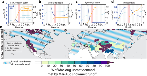
Figure 1. Snow resource potential in the present climate. (a)–(d) 1955–2005 March through February cumulative unmet demand (UD), orange, and snowmelt runoff (snmQ), light blue, both referenced to the right axis (mm) and their ratio (snmQ/UD), dark blue, referenced to the left axis (snmQ/UD), for example basins: the San Joaquin (a), Colorado (b), Syr Darya (c) and Indus (d). In each panel, August is highlighted in red to show the value plotted in (e), which is the August snmQ/UD cumulative ratio multiplied by 100, or what we term, the 'snow resource potential'. (e) The snow resource potential. Blue-stripped regions indicate basins for which instantaneous monthly rainfall runoff is sufficient to meet all March–August basin-scale demand. White regions have no snowmelt runoff.
Download figure:
Standard image High-resolution imageWe estimate March–August rainfall runoff, snowmelt runoff, unmet demand, and snow resource potential for the 'historical' (1955–2005) and 'future' (2006–2080) periods in reanalysis (historical) and in transient climate simulations (historical and future). For the historical period, we rely on version 2 of the Global Land Data Assimilation System (GLDAS)—a 0.25° gridded reanalysis of surface land variables—to provide estimates of observed land surface processes (Rodell et al 2004). The estimates from this dataset provide an observed climatological baseline against which to evaluate projected future changes.
We use two global climate model ensembles forced in the IPCC AR5 RCP8.5 emissions pathway (Riahi et al 2011) to simulate both historical and future snowmelt runoff and rainfall runoff (supplementary material). RCP8.5 provides the emissions pathway most similar to observations since 2005 (Peters et al 2013). We use these two ensembles forced in RCP8.5 to capture several different sources of uncertainty in the projections of future climate. The first is the Coupled Model Intercomparison Project (CMIP5) (Taylor et al 2012), which includes GCMs that simulate coupled interactions among the atmosphere, ocean, land, and sea ice at varying resolutions (Taylor et al 2012, Flato et al 2013). We use one run from the 19 CMIP5 models that provide the requisite output fields providing a 19-member CMIP5 ensemble (table S1). The second ensemble is NCAR's single-model 'large ensemble' (LENS), which consists of 30 simulations of the Community Earth System Model (CESM) (Kay et al 2015). CESM is a coupled atmosphere–ocean–land–sea-ice model that simulates climate at 1° × 1° atmospheric resolution. LENS encompasses 30 simulations of the climate from 1920 to 2080, using both observed and projected (RCP8.5) forcing. Each LENS member is initialized with the same ocean and sea-ice conditions, with the only difference being small perturbations to the initial atmospheric state.
In analyzing both CMIP5 and LENS in a single forcing pathway, our estimations of risk of future declines in the snow resource potential come from two sources of ensemble uncertainty. CMIP5 provides a range from an undetermined combination of model structure and internal variability, while the LENS provides an estimate of 'irreducible' uncertainty from CESM's representation of internal climate variability (Deser et al 2012a, 2012b, Kay et al 2015, Mankin and Diffenbaugh 2015). Internal variability exerts a large influence on long-term hydroclimate and snow accumulation (Rauscher et al 2008, Kapnick and Delworth 2013, Mankin and Diffenbaugh 2015), which can create an irreducible range of uncertainty on multi-decadal time scales.
We convert all gridded data to mm/month and compute area-weighted averages for basins demarcated by a modified version of the Simulated Topological Network 30p (STN-30p) (Vörösmarty et al 2000). STN-30p is a 0.5° resolution dataset representing the spatial extent of drainage basins. We modify STN-30p using the coastal basins of (Meybeck et al 2006) to aggregate small coastline basins into larger basins following the methods of (Viviroli et al 2007). We analyze basins with centroids >10 °N latitude, and mask small basins for which the GLDAS 0.25 data are too coarse, providing 421 NH basins for our analysis. Gridded human population estimates for 2015 are retrieved from the Center for International Earth Science Information Network (CIESIN, FAO & CIAT 2005).
We calculate basin-scale monthly-mean linear trends in snowmelt runoff and rainfall runoff from 2006 to 2080 in each of the CMIP5 and LENS realizations, yielding time trend coefficients based on the 75 year basin-scale time series. We express each simulation's linear time trend relative to its respective historical (1955–2005) monthly mean climatology. We present these time trends as percent change per 50 years. To account for biases in the CMIP5 and LENS simulations, we project these relative changes in snowmelt runoff and rainfall runoff onto the GLDAS historical monthly mean climatology. We multiply each realization's monthly relative trend (fraction of that realization's historical mean) by the GLDAS monthly value. We add this relative change to the GLDAS baseline monthly mean, providing 49 estimates of absolute change (19 CMIP5, 30 LENS) in future monthly snowmelt runoff and rainfall runoff in each basin. We then estimate the future unmet demand and snow resource potential for each realization, and difference it from the GLDAS-based observational baseline. This method is similar to the statistical change factor method used to downscale climate data (Minville et al 2008, Chen et al 2011); however, rather than projecting onto daily-scale observations, we add the relative changes in the future monthly means to observed monthly means. Following the IPCC (Collins et al 2014, Diffenbaugh et al 2014), risks are calculated as the percent of the ensemble that agrees on the direction of change.
Results
We show the basin-scale evolution of spring and summer snowmelt runoff and unmet demand for the San Joaquin, Colorado, Syr Darya, and Indus basins (figures 1(a)–(d)). The observed seasonal relationship between snowmelt runoff and unmet demand is basin-dependent. For instance, in the agriculturally intensive San Joaquin, unmet demand begins to accumulate in May as snowmelt runoff slows. The mismatch in runoff timing suggests the importance of storage reservoirs to supplying water during the dry season, which is also when agricultural demand, and thus unmet demand, is highest. By August, the snow resource potential is ∼17% of unmet demand. In contrast, in the Indus basin, where the sub-annual evolution of human water demand and rainfall runoff is quite different than the San Joaquin, the August snow resource potential is ∼180%.
Snowmelt runoff is a spatially dominant feature of the NH spring and summer hydrological regime: 305 of the 421 basins have March–August snowmelt runoff. Yet despite snowmelt runoff's ubiquity, more than two-thirds of NH basins (280 of 421) have sufficient spring and summer rainfall runoff to meet all spring and summer human demand (figure 1(e)). Of these 421 basins, we identify 97 snow-sensitive basins (i.e., basins with both climatological spring–summer snowmelt runoff and unmet demand). These basins are presently home to ∼1.9 billion people. The snow-sensitive basins are geographically limited to approximately 25–45 °N (near the sub-tropical high pressure centers) (figure 1(e)). Notable exceptions are the extremely high latitudes, where human populations are low and all human water demand can be met by runoff from snowmelt.
For many snow-sensitive basins, spring–summer snowmelt runoff exceeds unmet demand many times over, meaning that even large decreases in snow supply may not pose risks for human water consumption. However, at least 46 basins have snowmelt runoff fulfilling unmet demand. These 46 basins are currently home to 1.5 billion people. For example, in the Ganges–Brahmaputra, where 700 million people live, ∼76% of unmet demand can be supplied by snowmelt runoff. In the Shatt al-Arab basin that spans much of the Middle East, the snow that accumulates in the Zagros Mountains can supply ∼56% of the spring and summer total unmet demand for its ∼67 million people.
Using the LENS and the CMIP5 model projections, we examine the risks of increases in unmet demand and decreases in snow resource potential (figures 2(a) and (b)). Decreases in spring and summer rains pose the risk that some basins that currently have enough rainfall to meet human water demand (hatched basins in figure 1(e)) may transition to having unmet demand by 2060 (gray basins in figures 2(a) and (b)), even without considering possible future increases in human demand. In the CMIP5 ensemble-mean, 68 basins (with >319 million people) transition from sufficient to insufficient instantaneous rainfall runoff for human consumption, including the Mississippi basin in central North America. In LENS, 31 basins (totaling ∼100 million people presently) transition to having net unmet demand profiles in the future (figure 2(b)).
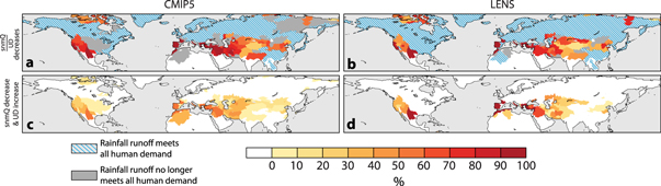
Figure 2. Risks of decreased March–August snowmelt supply and increased unmet demand by 2006–2080. For the CMIP5 (left column, (a), (c)) and the LENS (right column, (b), (d)), we show the risks of decreases in snowmelt resource potential in (a), (b). Basins with blue lines indicate basins for which future rainfall runoff is sufficient to meet present human water demands. (c), (d) Basins with joint risks for both snowmelt decreases and unmet demand increases. Gray basins in (a) and (b) indicate basins that shift from sufficient to insufficient rainfall runoff to meet water demand in the ensemble-mean. These basins are projected to be snowmelt dependent. Their ensemble-mean snow resource potential projections are shown in figure S1.
Download figure:
Standard image High-resolution imageThe 97-basin mean risk of decreased snow resource potential is greater than 60%: it is 67% for CMIP5, and 64% for LENS. A decrease in the snow resource potential is governed by a combination of sub-annual changes in rainfall runoff (which can change the spring and summer unmet demand profile), and by changes in the magnitude and timing of snowmelt. We therefore calculate the joint risk of combined decreases in snowmelt runoff and increases in unmet demand (figures 2(c) and (d)). In CMIP5, 20 basins (with ∼27 million people) exhibit >50% risk of both increased unmet demand and decreased snowmelt runoff, while in LENS, 6 basins (with >10 million people) have >50% risk (figures 2(c) and (d)) by 2060.
While the risk of decreasing snow resource potential is large in many basins (figure 2), there is substantial uncertainty in the fraction of unmet demand that is likely to be met by snowmelt runoff by 2060 (denoted by basin stippling in figures S1(b) and (c), which shows the CMIP5 and LENS ensemble mean projections). Indeed, for both the multi-model CMIP5 ensemble and the single-model LENS ensemble, the majority (∼90%) of snow-dependent basins span positive and negative changes in the snow resource potential (figures 3(a)–(f)). Only three basins show declines across all realizations in both ensembles, all three of which exhibit low snow volumes in the baseline climate: on the Iberian and Italian peninsulas (the Duero-Adour and Central Apennines respectively), and in the Rio Grande basin spanning Texas and Mexico. The lack of unequivocal robustness in both the CMIP5 and LENS ensemble-mean responses highlights the large variations in the long-term future snow resource potential. In particular, the fact that the single-model LENS ensemble does not simulate a consistent sign of change in a number of basins suggests that much of the uncertainty in future snow resource potential can arise from internal variability.

Figure 3. Ensemble range in snow resource potential change at 2060. For each ensemble, CMIP5 (left column, (a), (c), (e)) and the LENS (right column, (b), (d), (f)) we show the full ensemble range in the change of future snowmelt supply potential differenced from the present potential, expressed as percentage points: the basin minimum (a), (b), the ensemble mean (c), (d), and the basin maximum. (e), (f) Gray basins are those for which future rainfall runoff is insufficient to meet human water demand. Stippled basins in (c), (d) indicate basins for which the ensemble-mean trend is less than 1 SD of the ensemble variability.
Download figure:
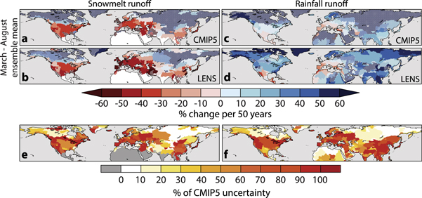
Standard image High-resolution imageTo quantify the potential basin-scale interactions of rainfall and snowmelt runoff in determining future snow resource potential, we calculate the seasonal average (March–August) ensemble-mean trends in snowmelt and rainfall runoff in CMIP5 and LENS (figure 4). For snowmelt runoff, the ensembles show similar patterns of high-latitude increases and mid-latitude decreases (figures 4(a) and (b)). Along with projected increases in warm-season precipitation, there is an increase in spring and summer rainfall runoff in the high and mid-latitudes (figures 4(c) and (d)). For most basins, decreases in snowmelt runoff are associated with increases in rainfall runoff, suggesting that at least some of the decrease in snowmelt runoff results from a transition of precipitation from snowfall to rainfall. The exception is a collection of basins in Central America, the Mediterranean, and Central Asia that exhibit declines in both snowmelt and rainfall runoff. Like the ensemble-mean changes in the snow resource potential, there are large uncertainties in the magnitude of the ensemble-mean trends in rainfall and snowmelt runoff, indicated by the vast stippled areas in figure 4. For both rainfall runoff and snowmelt runoff, the variability in the seasonal trends within LENS spans a large percentage of the CMIP5 variability, including many of the snow-sensitive basins identified in our analysis, particularly around the Western US and the Mediterranean (figures 4(e) and (f)). As with the snow resource potential, the fact that the LENS range spans a large fraction of the CMIP5 range suggests that much of the multi-model uncertainty could arise from internal climate variability.
Figure 4. Ensemble-mean trends from CMIP5 and LENS. (a), (b) March–August ensemble-mean linear snowmelt runoff trends, estimated from 2006 to 2080 in the CMIP5 (a) and LENS (b), expressed as percent change per 50 years. (c), (d) As in (a) and (b) but for rainfall runoff. (e), (f) The percent of the variability in CMIP5 trends in snowmelt runoff (e) and rainfall runoff (f), spanned by the LENS ensemble. Stippled basins in (a)–(d) indicate basins for which the ensemble-mean trend is less than 1 SD of the ensemble variability.
Download figure:
Standard image High-resolution image
To identify the basins that are most likely to be sensitive to snow supply changes, we highlight key results for basins that meet the following criteria: (1) basins with a March–August snow resource potential of 1–250% in the observed historical baseline, and (2) a present population of over 1 million people. Together, these criteria focus our analysis on large or population-dense basins. In particular, the 1–250% inclusion criterion emphasizes places where snowmelt runoff has a non-zero potential to supply unmet demand but does not exceed unmet demand so many times over that the basin is potentially insensitive to changes in snowmelt or rainfall runoff.
We find that 32 basins, encompassing ∼1.45 billion people, meet these criteria (table 1, map inset). Particularly sensitive basins include the Kizil Irmak (basin ID 14), Asi (basin ID 15), Asksu (basin ID 16), and Aegean (basin ID 11) in the Mediterranean region, and the Ebro-Duero (basin ID 9) on the Iberian Peninsula. These five regions show 100% risks of declining snow resource potential across the 19 CMIP5 models. In contrast, the highly populous Indus river basin (∼270 million) has lower risks of decreased snow resource potential, in part due to modest increases in rainfall runoff projected in LENS, and modest but uncertain increases in snowmelt runoff in the CMIP5.
Table 1.
Risk profiles of snow sensitive basins. We show the 32 snow sensitive basins that meet the following criteria: (1) observed late 20th century snowmelt runoff is 1—250% of unmet demand, making it sensitive to changes in water supply and (2) more than 1 million inhabitants. For these 32 basins, totaling 1.45 billion people, we show the observed snowmelt dependency, the risk of decreases in this measure in both the CMIP5 and LENS ensembles. Outlined in red are the four additional basins that do not meet the 1 M inhabitant threshold, but have population densities >5 people/km2: [a] Klamath Basin (snmQ/UD: 125%; CMIP risk: 79%; LENS risk: 93%); [b] Western Great Basin (snmQ/UD: 239%; CMIP risk: 74%; LENS risk: 33%); [c] North Black Sea-Crimea (snmQ/UD: 2%; CMIP risk: 94%; LENS risk: 100%); and [d] Western Dzungarian (snmQ/UD: 95%; CMIP risk: 47%; LENS risk: 73%).
| # | Name | Population (mil.) | snmQ/UD index (%) | CMIP Risk (%) | LENS Risk (%) |
|---|---|---|---|---|---|
| 1 | Sacramento | 4.93 | 25 | 95 | 87 |
| 2 | Coastal California | 3.73 | 2 | 89 | 73 |
| 3 | San Joaquin | 6.30 | 17 | 95 | 90 |
| 4 | Colorado (South) | 1.21 | 1 | 74 | 50 |
| 5 | Upper Great Basin | 2.44 | 46 | 63 | 50 |
| 6 | Colorado | 9.65 | 207 | 74 | 50 |
| 7 | Rio Grande | 16.46 | 114 | 95 | 100 |
| 8 | Atlas | 25.48 | 2 | 95 | 100 |
| 9 | Ebro-Duero | 32.20 | 10 | 100 | 100 |
| 10 | South Apennines | 1.13 | 3 | 95 | 97 |
| 11 | Aegean | 12.14 | 35 | 100 | 97 |
| 12 | Buyuk Menderes | 9.74 | 8 | 95 | 100 |
| 13 | Sakarya | 1.29 | 179 | 95 | 70 |
| 14 | Kizil Irmak | 6.38 | 24 | 100 | 80 |
| 15 | Asi | 19.19 | 15 | 100 | 97 |
| 16 | Aksu | 1.97 | 151 | 100 | 90 |
| 17 | Dead Sea | 15.71 | 1 | 84 | 77 |
| 18 | Shatt al Arab | 67.44 | 56 | 95 | 73 |
| 19 | Urmia | 5.25 | 26 | 68 | 57 |
| 20 | South Caspian | 8.41 | 18 | 95 | 67 |
| 21 | Masileh | 21.23 | 16 | 79 | 70 |
| 22 | Karun | 13.85 | 1 | 79 | 70 |
| 23 | Garagum | 9.68 | 3 | 79 | 73 |
| 24 | Farah | 12.74 | 164 | 79 | 70 |
| 25 | Syr Darya | 27.14 | 50 | 58 | 60 |
| 26 | Ili | 4.46 | 34 | 47 | 50 |
| 27 | Alakol | 1.72 | 44 | 53 | 47 |
| 28 | Dzungarian | 10.74 | 16 | 53 | 73 |
| 29 | Upper Ili | 1.11 | 2 | 68 | 67 |
| 30 | Indus | 269.43 | 105 | 37 | 33 |
| 31 | Ganges | 696.82 | 77 | 63 | 47 |
| 32 | Huai | 131.59 | 1 | 58 | 37 |
Discussion
Our measure of snow resource potential is defined by two requisite factors: that NH spring and summer snowmelt runoff is a climatological feature of the hydrological basin, and that human water consumption exceeds water available from instantaneous rainfall runoff. This formulation allows us to focus explicitly on the potential of the snow resource to supply human water demand that is not met by rainfall. However, because snow is not the only source of water storage for humans, and because snow is also critical for fulfilling water demanded by ecosystems, a number of caveats beyond the assumption of the RCP8.5 scenario must be considered.
First is that our measure does not consider the needs of each basin's environmental runoff requirements, nor how changes in snowmelt timing will affect ecosystems and their required nutrient loadings (Pierson et al 2013). Warmer temperatures imply greater potential evapotranspiration and probable changes in soil moisture during the dry season (Seneviratne et al 2010). Further, a snow-to-rain phase change could potentially decrease streamflow (Berghuijs et al 2014), suggesting the possibility of net runoff decreases in warming basins irrespective of precipitation changes. Neither the ecological contributions to total water demand nor the ecological consequences of these shifts in basin hydrology are captured in our analysis.
Second is our treatment of the human dimension. Total human population—and thereby total water demand—will almost certainly increase in the future. However, we do not predict changes in total population or the geographic distribution of people, nor the changes in consumption patterns that are likely to accompany future socioeconomic changes. To do so would introduce additional sources of uncertainty, whereas our aim is to isolate the uncertainty from climate change. The likelihood that population growth and economic development increase human water demand in the future implies that our analysis provides a lower bound on the risks that global warming will present to snow resource potential, as increasing population and/or per capita consumption will further increase the total amount of water required to meet human demand.
Third is that our measure of snow resource potential quantifies the size of the snow water resource given climatological factors and present human water demand, but does not consider whether basin-scale water availability is sustainably managed. The basins that we identify as being sensitive to snow changes, for example, may have sufficient surface storage infrastructure or groundwater resources to ensure water supply during months of shortfall, rendering snowmelt runoff less critical for meeting unmet demand. Conversely, a number of rainfall-sufficient basins (hatched regions in figures 1–3) may be reliant on the extra volume of water provided by snowmelt runoff for hydropower or other managed systems (Rauscher et al 2008), or may not be positioned to collect and store all the rainfall runoff within the basin. Furthermore, our analysis of the most sensitive basins includes a minimum population criterion of 1 million people (table 1). It is possible that adjacent basins with smaller populations could together represent areas of equivalent exposure when considered together as a contiguous unit. If basin-scale population densities of at least 5 people per km2 are considered rather than population totals, four additional basins meet the inclusion criteria presented in table 1.
It should be noted that the assumption of the RCP8.5 pathway, which is the highest available in the AR5, could influence not just the risks of decreased snow resource potential for basins, but also the relative magnitudes of the basin-scale uncertainties between the CMIP5 and LENS. Presumably, the expression of internal variability in both ensembles will represent an increasing fraction of total uncertainty under lower emissions trajectories. How this will change the relative magnitudes of uncertainty between the CMIP5 and a LENS-like experiment requires further testing.
Fourth, there are several spatial and temporal factors that influence our analysis, and therefore our results. Because we consider the size of the snowmelt resource over a 6-month window (March–August), the temporal scale we consider is too coarse to identify subtler, but potentially critical, shifts in snowmelt runoff peaks that change dry season lengths (Rauscher et al 2008, Ashfaq et al 2013). There are also considerable sub-basin heterogeneities (such as from topography or soil heterogeneity) that can influence the timing and magnitude of observed water availability at smaller temporal scales (Rauscher et al 2008, Adam et al 2009). The scale at which snow and snowmelt runoff are resolved in models is also a critical limitation (Rauscher et al 2008, Pavelsky et al 2012, Ashfaq et al 2013). The CMIP5 ensemble has divergent estimates of snow accumulation (Diffenbaugh et al 2012). Sources of model divergence in estimates of snow include (1) simulations of synoptic-scale atmospheric processes that create snowfall, model representations of topography (Mote 2006), and fine-scale processes that are parameterized at sub-grid-scales in the models, such as snow albedo and cloud feedbacks (Qu and Hall 2006, 2014). Such limitations influence model bias and therefore, ensemble-mean bias. This is a justification for examining the full distribution of snow-related changes produced by the both the CMIP5 and LENS and comparing their relative spans as in figure 4. However, it should be emphasized that neither ensemble explicitly resolves all of the processes that create snowfall and snowmelt.
The different means by which models treat these snow-related processes is often cited as the reason for the large multi-model uncertainty in CMIP5 (Rauscher et al 2008, Ashfaq et al 2013). However, our results suggest that irreducible uncertainty from model representations of internal variability at coarse spatial scales can span a similarly large uncertainty (figures 4(e) and (f)). It is important to note that the similar range of uncertainty in future snowmelt in the LENS and CMIP5 in some basins may not hold for simulations at finer scales that better resolve the atmosphere and land surface (Rauscher et al 2008). In higher resolution simulations, the magnitude of warming appears to be sufficiently large to overwhelm fine-scale precipitation variability arising from complex topography (Ashfaq et al 2013). It remains, however, that the large uncertainties within the single-model LENS ensemble highlight the potential for internal variability to exert a large influence on monthly-scale hydroclimate, and therefore risks of declines in snow resource potential. Furthermore, the magnitude of the LENS uncertainty suggests the possibility that, for some climate impacts, the fraction of total CMIP5 ensemble uncertainty contributed by internal variability may be larger than the fraction contributed by model differences.
Conclusions
Our estimate of snow resource potential provides a meaningful baseline for quantifying the risk that different regions face from changes in climate (such as from global warming or internal climate variability) and/or changes in demand (from population or land-use change). It can also be reconciled against analyses of basin-scale vulnerability and adaptation capacity (World Water Assessment Programme 2009).
We conclude that, should greenhouse gas emissions continue along their recent trajectory, which is at or above the RCP8.5 scenario analyzed here (Peters et al 2013), the risks of declines in snow resource potential exceed 67% in snow-sensitive basins, potentially impacting spring and summer water availability for nearly 2 billion people. In the CMIP5 ensemble-mean, global warming also shifts an additional 68 basins to have spring and summer rainfall runoff that is insufficient to meet human water demand, even without accounting for increases in demand that are likely to arise from population growth and economic development. These basins are particularly critical, as emerging increases in unmet demand must be supplied by alternative sources, in many cases within the context of decreasing snow resource potential.
Our results highlight the basins where future snow changes pose the greatest risk to people's present water demand patterns. We present these risks in the context of climate uncertainty, including the irreducible uncertainty from internal climate variability. Given present demand, this irreducible range is sufficient to create ambiguity in the sign of decadal trends in future snow resource potential. A number of other uncertainties exist in future water resources from snow, many of which reside in the human dimension, including where and how people manage and respond to water resources in a changing climate. Our results provide critical context for climate risk management (Milly et al 2008, Kunreuther et al 2013) and robust adaptation decisions (Lempert and Collins 2007, Milly et al 2008, Kunreuther et al 2013) that require identification of critically snow-dependent basins and quantification of irreducible uncertainty in future climate trajectory.
Acknowledgments
The authors would like to thank the World Climate Research Program and Department of Energy's Program for Climate Model Diagnosis and Intercomparison for access to the CMIP5 simulations; NCAR's CESM1 (CAM5) Large Ensemble Community Project (LENS); Matthew Rodell and NASA's GES DISC for assistance with GLDAS data access and interpretation; and supercomputing resources provided by NSF/CISL/Yellowstone and Stanford CEES. Our work was supported by a Predoctoral Science Fellowship at the Center for International Security and Cooperation (CISAC) at Stanford University to JSM, and NSF CAREER Award 0955283 to NSD.