(A) Definition and purpose of bufferyards.
(1) BUFFERYARD is a unit of yard together with the planting required thereon.
(a) Both the amount of land and the type and amount of planting specified for each bufferyard required by this chapter are designed to ameliorate nuisances between adjacent land uses, or between a land use and a public road.
(b) The planting units required of bufferyards have been calculated to ensure that they do, in fact, function to buffer.
(2) Bufferyards shall be required to separate different land uses from each other, in order to:
(a) Eliminate or minimize potential nuisances, such as dirt, litter, noise, glare of lights, signs, and unsightly buildings or parking areas; or
(b) Provide spacing to reduce adverse impacts of noise, odor, or danger from fires or explosions.
(B) Location of bufferyards.
(1) Bufferyards shall be located on the outer perimeter of a lot or parcel, extending to the lot or parcel boundary line, except as provided below.
(a) For those properties designated as "Areas of Purview" within the Commercial Design Review Overlay District, and having separate lots within a larger development (such as an "outparcel"), the necessity of whether a bufferyard is required, and the specific requirements thereof, shall be determined during the Design Review Process.
(b) Where two commercial parcels share vehicular access along an adjoining property line, the adjoining buffers along the property line where interconnection occurs may be eliminated to the extent that the two parcels connected are adjoining. Where this shared access occurs, the buffer may further be eliminated where the two parcels share a fully cohesive interconnected parking lot. Portions of a parcel not interconnected shall be required to provide the buffer as normally required.
(c) Bufferyards shall not apply to lot lines for lots subdivided pursuant to the provisions of § 155.047(C)(1)(a) and (b); provided, however, that required buffers shall be in accordance with the provisions above, as applicable; i.e., on the parcel perimeter or as prescribed by the Design Review Process.
(2) Bufferyards shall not be located on any portion of an existing public or private street or right- of-way, except as provided herein.
(3) Buffers shall not be placed such that they overlap utility easements due to the conflict with tree growth. Otherwise, buffers may only overlap easements with written permission from the easement holder. In cases where the easement holder does not provide an agreement, the buffer shall be provided outside of the easement.
(C) Determination of bufferyard requirements. To determine the bufferyard required between two adjacent parcels or between a parcel and a street, the following procedure shall be followed:
(1) Identify the proposed land use.
(2) Identify the use of land adjacent to the proposed use.
(3) Use of table.
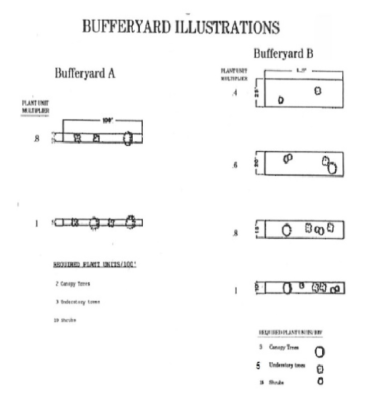
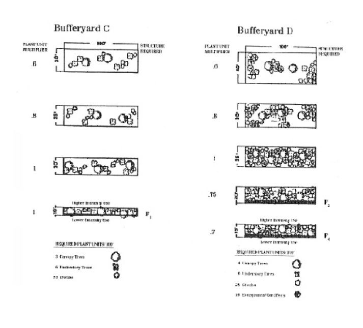
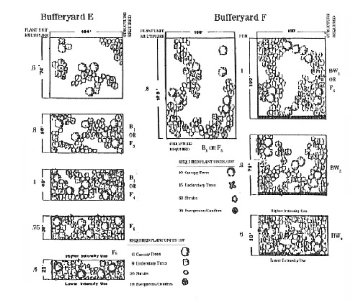
(a) Determine the bufferyard required on each boundary of the subject parcel by referring to the following Table of Bufferyard Requirements, and illustrations that specify the bufferyard required between streets and adjacent land uses.
(b) The letter designations contained in the table refer to the type of bufferyard specified by the illustrations contained in this section.
(4) Any of the several options contained in the illustrations shall satisfy the requirement of buffering between adjacent land uses and streets.
(5) Provided, however, that where bufferyard requirements change along a property line because of abutting land uses, the bufferyard width and plant schedule shall be the average of the total required, with consideration given towards the appropriate fence structure, if applicable, during the approval process.
(6) Further provided, however, that for those properties designated as “Areas of Purview” within the Commercial Design Review Overlay District that abut passive areas, where existing vegetation may be present that will not be removed in the future, such as wetlands, easements, ponds, highways, roads and the like, the quantity of bufferyard plantings shall be determined during the Design Review Process. The minimum bufferyard width shall remain as specified in the Table of Bufferyard Requirements and shall not be reduced.
(D) Bufferyard specifications.
(1) The following illustrations graphically indicate the specifications of each bufferyard.
(a) The requirements are stated in terms of the width of the bufferyard and the number of plants required per 100 feet of bufferyard.
(b) The requirements of a bufferyard may be satisfied by any one of the options illustrated.
(c) The plant unit multiplier is a factor by which the basic number of plant materials required for a given bufferyard is determined, given a change in the width of that yard.
(d) The type and quantity of plant materials required by each bufferyard and each bufferyard option are specified by the following illustrations.
(e) Each illustration depicts the buffer to be provided on a given property, which is a portion of the total buffer to be provided between two adjoining developed parcels.
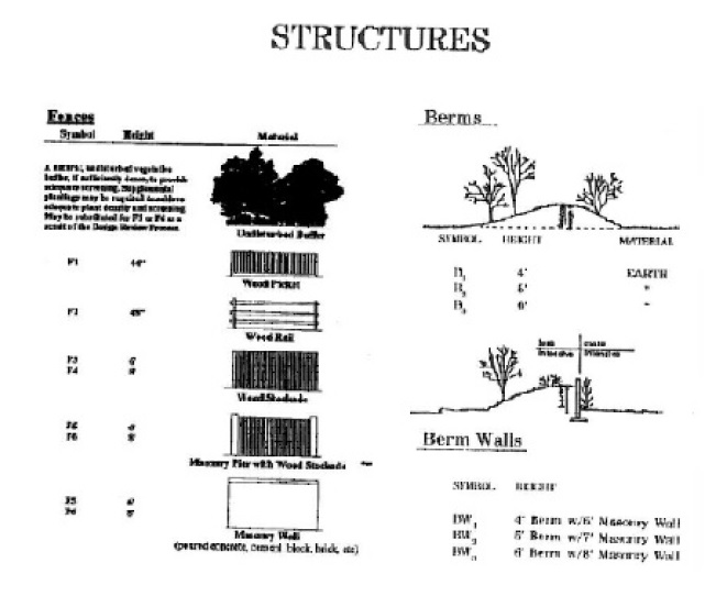
(f) Whenever a wall, fence or berm is required within a bufferyard, these are shown as structures in the following illustrations, wherein their respective specifications are also shown.
(g) Any existing plant material that otherwise satisfies the requirements of this section, may be counted toward satisfying the required bufferyard.
(2) The type of required structure and exact placement of required plants shall be determined through the design approval process, based upon the proposed use of the subject property and the uses of adjoining properties: and in the case of fence structures, the type of materials utilized and maintenance issues; and further provided that evergreen (or conifer) plant materials shall be planted in clusters.
(3) All bufferyard areas shall be seeded with lawn grass, mulch or suitable ground cover, except as approved by staff or the Design Review Board.
Table of Bufferyard Requirements
| ||||||||||||
Existing Adjacent Land Use
| ||||||||||||
Proposed Land Use
| Single- Family Detached
| Duplexes/ Townhouses | Mobile Home
| Agricultural
| Mixed Use
| Religious, Education, Rec., Day Care, Nursing Home
| Commercial Office, Institutional
| Industrial
| Vacant Land2 | Street3 |
All Other
| |
Duplexes/ Townhouses4 |
C
|
A
|
B
|
B
|
E
|
B
|
B
|
B
|
B
|
B/A
|
B
|
B
|
Multi-family or Group
Dwelling4 |
D
|
B
|
A
|
B
| B
|
B
|
B
|
B
|
B/A
|
B
|
B
| |
Mixed Use
|
E
|
C
|
C
|
A
|
D
|
C
|
C
|
C
|
C
|
C/A
|
B
|
C
|
Religious, Education, Recreation, Day Care, Nursing Home
|
D
|
D
|
C
|
C
|
B
|
B
|
B
|
B
|
C
|
B/A
|
B
|
B
|
Commercial Office, Institutional
|
E
|
D
|
D
|
C
|
B
|
A
|
B
|
A
|
B
|
C/A
|
B
|
B
|
Industrial1 |
F
|
F
|
E
|
E
|
D
|
D
|
E
|
D
|
D
|
D/A
|
B
|
D
|
All other uses except those for which buffers and screens are specified elsewhere by this chapter
|
E
|
D
|
D
|
A
|
B
|
B
|
B
|
A
|
B
|
C/A
|
A
|
B
|
1. Includes all uses permitted in the LI District. 2. First letter designates bufferyard for vacant land zoned Residential, second letter designates bufferyard for all other land. 3. Where proposed land uses are to be constructed adjacent to streets, a type “B” bufferyard shall be required between the proposed use and the street. 4. For Duplexes/Townhouses uses and Multi-family or Group Dwelling uses, the required buffer shall be located on the exterior perimeter of the development project only, and not applicable to individual buildings, driveway accesses or streets within the project development interior. | ||||||||||||
(E) Use of bufferyards. A bufferyard may be used for passive recreation; however, no plant material may be removed.
(F) Bufferyards part of required yards. Where front, side, and rear yards are required by this chapter, bufferyards may be established within such required yards.
(G) Plant species. The following list of plants is a guideline to determine which plants may be used to satisfy the requirements of this chapter. Plants not listed may be approved by staff; however, to encourage a diversity in plantings, the town shall require at least 50% of the total quantity of canopy and understory trees to be native species.
(1) Town canopy tree list | (2) Town understory tree list | (3) Town shrub list |
(1) Town canopy tree list | (2) Town understory tree list | (3) Town shrub list |
American Beech# | American Hop Hornbeam# | Abelia |
American Elm# (Dutch elm disease-resistant) | American Hornbeam# | American Beautyberry |
American Holly# | Autumnalis Cherry | Anise |
American Sycamore# | Black Cherry# | Assorted Andromeda |
Amur Maple | Assorted Azaleas | |
Armstrong Maple | Burford Holly | Aucuba |
Bald Cypress# | Carolina No. 2 Holly | Banana Shrub |
Black Gum# | Carolina Silverbell# | Barberry |
Black Walnut# | Chastetree | Blue Hetzi Juniper |
Chinese Elm | Cherry Laurel# | Blue Pfitzer Juniper |
Chinese Evergreen Oak | Chinese Holly | Blue Point Juniper |
Chinese Flame Tree | Chinese Redbud | Boxwood |
Chinese Pistache | Crabapple | Burning Bush |
Darlington Oak# | Crape Myrtle (as accent only) | Camellia |
Dawn Redwood | Dahoon Holly# | Carissa Holly |
Deodar Cedar | Devilwood# | Chastetree |
Eastern Red Cedar# | East Palatka Holly | Chinese Witch Hazel |
Florida Flame Red Maple# | Eastern Redbud# | Clethera |
Florida/Southern Sugar Maple# | Emily Bruner Holly | Coast Leucothoe |
Ginkgo | Florida Anise | Common Fig |
Golden Raintree | Flowering Dogwood# | Compact Cherry Laurel |
Green Ash# | Foster No. 2 Holly | Compact Japanese Holly |
Hackberry# | Franklinia# | Compact Mock Orange |
Japanese Evergreen Oak | Fringe Tree# | Compact Pfitzer Juniper |
Japanese Maple | Groundsel Bush# | Convex Holly |
Katsuratree | Hollywood Juniper | Cotoneaster |
Laurel Oak# | Hume No. 2 Holly | Dazzler Holly |
Leyland Cypress | Japanese Flowering Cherry | Dwarf Burford Holly |
Live Oak# | Kousa Dogwood | Dwarf Chinese Holly |
Loblolly Pine# | Kwanzan Cherry | Dwarf Crape Myrtle |
London Plane | Little Gem Magnolia# | Dwarf Palmetto |
Long Leaf Pine# | Loblolly Bay# | Dwarf Yaupon Holly |
Mockernut Hickory# | Loquat | Euonymous |
Myrimar Zelkova | Lusterleaf Holly | European Fan Palm |
Nuttall Oak# | Myrtle Oak# | Fatsia |
October Glory Red Maple# | Nellie R. Stevens Holly | Florida Leucothoe |
Overcup Oak# | Okame Cherry | Forsythia |
Pecan# | Persimmon# | Fortune's Osmanthus |
Pignut Hickory | Photinia Frasers | Gardenia |
Pin Oak | Pindo Palm | Heller's Japanese Holly |
Pond Cypress# | Podocarpus | Hetzi Japanese Holly |
Post Oak# | Possumhaw Holly# | Hibiscus |
Sabal Palm (use as accent only with staff/Design Review Board approval)# | Purple-leaf Plum | Hollywood Juniper |
Sawtooth Oak | Red Bay# | Hydrangea |
Scarlet Oak | Red Buckeye# | India Hawthorne |
Shag Bark Hickory# | Sabal Palm (use as accent only with staff/Design Review Board approval)# | Inkberry Holly |
Shumard Oak# | Sand Live Oak# | Japanese Anise |
Southern Magnolia# | Sassafras# | Japanese Aralia |
Southern Red Oak# | Saucer Magnolia "Jane" | Japanese Cleyera |
Summer Red Red Maple# | Savannah Holly | Leatherleaf Mahonia |
Swamp Chestnut Oak# | Sourwood | Majestic Beauty Hawthorne |
Southern Crabapple# | ||
Swamp Tupelo# | Star Magnolia | Needlepoint Holly |
Swamp White Oak# | Sweetbay Magnolia# | Oleander |
Sweet Gum * **# | Turkey Oak# | Oregon Holly Grape |
Sycamore# | ||
Trident Maple | Wax Myrtle# | Otto Luyken Laurel |
Tulip Poplar# | Weeping Cherry | Pineapple Guava |
Water Hickory# | Weeping Yaupon Holly# | Pink Flowering Quince |
Water Oak# | Yaupon Holly# | Pittosporum |
Water Tupelo# | Yoshino Cherry | Podocarpus |
White Ash# | Pyracantha | |
White Oak# | Roundleaf Holly | |
Willow Oak# | Sago Palm | |
Saw Palm | ||
Sizzler Holly | ||
Skip Laurel | ||
Spirea | ||
Stokes Holly | ||
Sweet Grass | ||
Sweetshrub | ||
Sweet Tea Olive | ||
Switch Grass (Panicum) (5'-8') | ||
Viburnum | ||
Virginia Sweetspire | ||
Wax Myrtle | ||
White Deutzia | ||
Windmill Palm | ||
Witch Hazel | ||
Yaupon Holly | ||
* These canopy trees are protected trees if located in a natural buffer. | ||
** The Sweet Gum is not a canopy replacement tree as provided in §§ 156.220 et seq. | ||
# These species are considered native species. | ||
(4) Invasive exotic species. On all properties except single-family residential, invasive exotic species listed as a severe or significant threat by the South Carolina Exotic Pest Council shall not be planted, or used to fulfill any buffer planting requirements. Where they exist on sites to be developed in part or in full, they shall be removed by appropriate means so as not to damage desirable species. No replacement is required for removal.
(5) Quality. Planted trees shall be of good structure and high quality.
(H) Minimum plant size.
Plant Material Type | Planting in Bufferyards Abutting Vacant Lands | All Other Planting |
Plant Material Type | Planting in Bufferyards Abutting Vacant Lands | All Other Planting |
Canopy Tree | ||
Single-stem caliper | 2-inch caliper | 2-1/2-inch |
Multi-stem caliper | 8-foot height | 10-foot height |
Understory Tree | ||
Understory tree | 6-foot height | 2-inch caliper |
Shrubs | ||
Deciduous/Evergreen | 15-inch height | 24-inch height |
Evergreen/Conifer | ||
5-foot height | 1-1/2-inch caliper | |
(I) Special bufferyards.
(1) Natural roadside buffer. A natural buffer shall be established on properties abutting all roadways designated as scenic highways, properties located within the Mount Pleasant/Charleston County Overlay District (provided that the natural roadside buffer on that portion of U.S. Highway 17 North that lies within the Mount Pleasant/Charleston County Overlay District shall commence at its intersection with Longpoint Road traveling north), S.C. Highway 41, or as may be determined during the planning process, i.e., impact assessment sketch plan approval by Town Council, sketch plan approval by Planning Commission, special exception approval by Board of Zoning Appeals, design review approval and staff approvals of smaller projects.
(a) Select clearing shall be allowed in these buffers of trees measuring less than three inches DBH.
1. All trees three inches DBH or greater shall be indicated on a tree survey.
2. Select pruning of limbs up to eight feet above ground level shall be permitted so long as it meets the pruning standards as provided in the latest version of ANSI 300.
(b)
Additional landscaping, irrigation and/or pedestrian trails must be approved by the Department of Planning, Land Use and Neighborhoods. Any plantings allowed or required within this buffer shall be native species. This buffer is intended to appear as a wooded strip and, thus, it shall be mulched and turf shall be prohibited.
(c) Cross-penetration of utilities in this buffer is discouraged and, to the extent possible, shall be brought in at other disturbed areas such as vehicular access points or sidewalk connections. Where these buffers are vegetated, utility cross- penetrations shall be bored under existing vegetation to avoid any disturbance to the buffer vegetation. In cases where no vegetation exists, trenched utility penetrations may occur; however, this work shall not disturb existing or planted vegetation with its installation, maintenance, or potential repairs.
(d) The boundaries of the natural roadside buffer shall be clearly delineated and identified on all development plans and plats submitted for approval.
(e) Clearing limits shall be staked out in the field in a manner approved by
Department of Planning, Land Use and Neighborhoods
staff prior to, and remaining through, construction activities.
(f) Buffer width to be determined in the planning process as specified in division (I)(1) above, but generally, the buffer should be 50 feet in depth along collector streets or minor arterials, and 100 feet in depth along major arterials; provided, however, exceptional conditions (such as project parcel size, the presence, or lack thereof, of existing natural vegetation, the dedication of right-of-way for frontage or access roads on the subject parcel, and the existence of utility or other easements or conditions that effect the buffer) shall be considered in making the buffer width determination.
(2) Critical line buffer. Except as expressly provided otherwise in the Zoning Code:
(a) A vegetated buffer shall be established along areas designated as tidally influenced "critical line" by SCDHEC-OCRM.
1. The entire buffer shall remain as an undeveloped vegetated area, except as provided herein.
2. The intent of this division is to prohibit grassed, manicured lawns within this buffer area.
(b) The natural vegetation in the buffer shall remain undisturbed, except as described in the vision corridor.
(c)
Vision corridors may be established through the critical line buffer in accordance with the following provisions:
1. The vision corridor may be established on properties where allowed and a critical line buffer has been provided. The effect of this should be a vertical corridor cut through the buffer, allowing a view through the critical line buffer.
2. The vision corridor must not exceed more than 1/3 of the square footage of the total critical line buffer area subject to the following provisions apply:
a. This area generally shall be formed by two near perpendicular lines connecting the critical line to the inland critical line buffer line;
b. The 33% vision corridor shall be one single uniform unbroken portion, except where it may be broken into increments no less than 25 feet in width; and
c. The vision corridor may be established on an adjoining property, provided the owner gives written consent.
3. Within the vision corridor, trees of a protected size for the lot shall not be removed. Smaller trees may be pruned or cut with hand tools, but the stump must remain in place. Grasses, shrubs and other smaller vegetation may be appropriately pruned and trimmed, but not removed at the root. No heavy equipment or herbicides are to be utilized in this area. The intent of this division is to ensure that the root mass remains intact to stabilize the ground surface preventing soil erosion.
(d) No uses shall be allowed in the critical line buffer, except the following:
1. A pedestrian access foot trail of pervious material parallel to the critical line.
2. Pedestrian or vehicular accessways leading to such water-dependent uses as docks, piers, bridges and boat landings.
a. These accessways must be elevated above grade to avoid channelization.
b. Such uses must be the minimum necessary to provide access.
3. Minimum utility line penetrations, as specifically and previously approved on development plans.
4. Use of swales or other means, rather than drainage pipes, shall be required.
5. Erosion control structure; with prior Office of Coastal Resource Management approval, and provided that the required buffer width is maintained or reestablished landward of the installed erosion control structure.
(e) Specific critical line buffers.
1. Critical line buffers initially established by these provisions shall continue subject to the following provisions:
a. Those located between the Cooper River Bridge and the Ben Sawyer Bridge shall be a minimum width of 15 feet.
b. Those located between the Cooper River Bridge eastward up the Wando River, and from the Ben Sawyer Bridge northward along the Intracoastal Waterway shall be an average of 35 feet in width with a minimum width of 20 feet.
c. The following are exceptions to these requirements:
(i) Lots of record and final plats approved prior to September 12, 2000, including a resurvey of an existing lot and any subsequent changes to the existing boundaries, provided no additional lots are created;
(ii) Valid approved preliminary plats as of September 12, 2000; or
(iii) Valid approved sketch plans adopted prior to the date of this section (September 12, 2000) shall be exempt for a period of two years from the date of approval of the sketch plan by the town. Subsequent preliminary plats must accurately reflect the sketch plan; otherwise, compliance with this division will be required.
2. Fifty-foot critical line buffer. A critical line buffer with an average width of 50 feet and a minimum width of 30 feet is hereby established as of November 13, 2018, with the following exceptions:
a. Those established under 1.c.i., ii. and iii. herein above.
b. Lots of record and final plats approved prior to November 13, 2018, including a resurvey of an existing lot and any subsequent changes to the existing boundaries, provided no additional lots are created;
c. Valid approved preliminary plats as of November 13, 2018; or
d. Valid approved sketch plans adopted prior to the date of this section (November 13, 2018) shall be exempt for a period of two years from the date of approval of the sketch plan by the town. Subsequent preliminary plats must accurately reflect the sketch plan; otherwise, compliance with this division will be required.
3. Fences, vertical retaining walls and like-mannered structures are also allowed within the critical line buffer; provided that the maximum horizontal distance of any above-grade component shall not exceed 12 inches in width.
(f) Critical line buffer and vision corridor delineation and record.
1. The boundaries of the critical line buffer shall be clearly delineated and identified on all development plans and plats submitted for approval. While vision corridors are not required to be established at the time of the final plat, there shall be a reference note on the final plat indicating the establishment of these corridors is necessary prior to the release of a building permit.
2. Once a building permit application is submitted, the vision corridor shall be delineated as an easement or deed restriction of the property on which it is located to act as a record of its establishment. The distances from rear and side property lines must be shown.
3. Subsequent changes to an established buffer or vision corridor must be re-approved and re-recorded, with restoration required for any previously disturbed bufferyard area, if necessary.
(g) Buffer limits shall be staked in the field in a manner approved by planning staff, prior to and throughout construction activities.
(h)
Critical areas by their very nature are dynamic systems, subject to change over time. Because of this, the limits of the critical line buffer shall be established by the final plat approved by the town and recorded with the Charleston County ROD Office. The buffer limits shall remain unchanged in perpetuity unless a new subdivision occurs. At such time, the critical line must be validated by the authorization of DHEC-OCRM, which will establish the current critical line location and thus the new buffer area; provided, however, the new setback location shall only apply to the subject property and not to adjoining property. In areas where the buffer has been averaged, the new buffer area shall not result in a reduction in square footage of the former buffer area previously established. It shall be the sole responsibility of the property owner to ensure all construction activity occurs landward of the current DHEC-OCRM critical line, irrespective of the critical line location reflected on the most recent recorded plat.
(i) Violation of this division (I)(2) or failure to comply with any of the requirements hereof shall be classified as a misdemeanor punishable by a fine in the amount of up to $500, or imprisonment for not more than 30 days, or both.
1. However, no penalty shall exceed the penalty provided by state law for a similar offense.
2. A separate offense shall be deemed committed for:
a. Each tree and/or separate plant or shrub identified in this code that is removed; and
b. Each day that the violation occurs or continues.
3. Any person, firm, organization, society, association, partnership, corporation, or like entity, or any agent or representative thereof, who commits, participates in, or assists in such violation may each be found guilty of a separate offense and suffer the penalties herein provided.
(j) Full restoration to a condition comparable to that which was destroyed shall be required within a specified period. If restoration is to be accomplished by the offending party, it shall include posting an acceptable financial guarantee with the town for the full amount of restoration required until the same is completed.
(k) Failure to comply with the terms stated in this division (I)(2) shall also be subject to enforcement in a circuit court of competent jurisdiction.
(3) Mathis Ferry Road buffer.
(a) Within the boundaries of the Mathis Ferry Road Plan (7th Avenue to Whipple Road), owners of all developed properties shall be encouraged to plant trees along their frontage with Mathis Ferry Road, to maintain the tree canopy along this scenic highway.
(b) New developments, redevelopments, and lot subdivisions shall be required to maintain a buffer, if the property is vegetated, prior to approval of development plans. This buffer shall remain natural and undisturbed; provided, however, that the removal of vines shall be allowed.
1. For single-family residential projects, this buffer shall be 25 feet;
2. For multi-family residential, 50 feet; and
3. For nonresidential, 75 feet.
(c) Invasive exotic species and vines. New developments, redevelopments and lot subdivisions shall be required to maintain a natural buffer, if the property is vegetated prior to approval of development plans. For this purpose, natural shall be defined as allowing only the removal of vines and invasive exotic species. New construction, additions to existing construction, and redevelopments shall be required to free their buffers from vines larger than one-quarter inch in diameter and exotic species as part of their construction plans. Property owners along this corridor are encouraged to regularly monitor their buffer and take measures to control vine and invasive exotic species growth to ensure a natural buffer.
(d) The boundaries of the Mathis Ferry Road buffer shall be clearly delineated and identified on all development plans and plats submitted for approval.
(e) Buffer limits shall be staked in the field in a manner approved by planning staff, prior to and throughout construction activities.
(4) Areas pertaining to all special bufferyards in which the natural vegetated buffer no longer exists, specifically including the natural roadside buffer, the critical line buffer and the Mathis Ferry Road buffer as provided herein.
(a) Areas that have been cleared prior to the initiation of a special bufferyard as provided herein shall be reconstituted as set forth below.
(b) All elements not allowed in the special bufferyard shall be removed, including existing turf.
(c) The special bufferyard shall then be mulched and replanted as prescribed herein per 100 square feet:
1. Two 3-gallon shrubs and two 7-gallon shrubs comprised of at least three differing species: and
2. One 1-1/2 inch understory tree and .5 2-1/2 half inch caliper canopy tree comprised of at least two differing species.
3. Plantings shall be indigenous to the immediate area and shall be arranged in a natural random pattern.
(d) If applicable, view corridors shall be established.
(5) Village scale pedestrian standards.
(a) Open space/parks.
1. A minimum of 8% of the development acreage, excluding the activity zone, shall be designed and utilized as open space and/or parks in the form of active and passive parks, plazas or public gathering spaces for any development project containing residential dwelling units.
2. Approval of the open space or park area shall be subject to Planning Commission or DRB approval.
(b) Activity zone.
1. Description. The activity zone is a quasi-public space that may be used for pedestrian circulation, placement of required canopy trees, planters, benches, trash receptacles, and other street furnishings, in addition to the uses described herein.
2. Location. Because the activity zone is specifically defined as the area between the street right-of-way line and build-to line, this means that an activity zone is not permitted where a setback is required.
a. On Coleman Boulevard, activity zones are expressly prohibited where a setback is required, as specified in the Coleman Development Guidelines Table.
b. Ben Sawyer Boulevard between its intersection with Coleman Boulevard and Chuck Dawley Boulevard east to Center Street Intersection.
c. On Johnnie Dodds Boulevard, activity zones are expressly prohibited on
the following neighborhood streets: Lansing Drive, Tall Pine Road, Dragoon Drive, Pine Hollow Road, Cottingham Drive, Williamson Drive, and the western side of Bowman Road between Johnnie Dodds Boulevard and Mathis Ferry Road.
d. On Chuck Dawley Boulevard, activity zones are permitted only on Chuck Dawley Boulevard. Activity zones are expressly prohibited on all side streets.
3. Permitted uses. All uses in the activity zone shall be conducted outside of the street right-of-way. Design review approval shall be required prior to establishing any use and/or installing any street furnishings within the activity zone. Allowed uses are limited to the following:
a. Streetside dining;
b. Outdoor merchandise display, which must be related to the business in front of which it is located;
c. Non-amplified music performers or entertainers, subject to the town's noise ordinance;
d. Pushcarts; and
e. One A-frame or sandwich board sign per business, subject to the requirements of the Signs subchapter. A-frame signs shall also require an approved sign permit.
4. Activity zone design standards.
a. Awnings may cover the entire activity zone area not utilized for canopy tree placement and as defined for streetside dining.
b. Awnings must comprise a minimum of five feet in depth, measured horizontally from face of building.
c. Awnings shall be a maximum of eight feet in height, measured from the bottom of an awning and/or valence to the sidewalk adjacent to building. This measurement may be adjusted for grand, multi-story windows.
d. Balconies. Balconies may project over the activity zone, but in no instance shall they extend over the right-of-way.
e. Support structures for awnings and balconies will not be permitted in activity zone.
f. Raised planters. In order to enhance the pedestrian-oriented theme of development, planters shall be required as a design element to soften the building exterior and enhance the streetscape.
g. Street furniture. Street furniture shall be utilized to enhance and facilitate the pedestrian experience and shall not be utilized as additional signage.
h. Pedestrian access to remain unimpeded. In all cases, permanent or temporary design features or activities shall not impede pedestrian access on the public sidewalk.
(c) Terminal vistas.
1. Properties that terminate views down streets shall be identified during the design review process, and will be held to a higher architectural standard along this visible facade.
2. Such identified properties are those that are across from side streets that intersect the primary boulevard and terminate or intersect and continue at a different angle.
3. Properties that are at the end of a straightaway on the boulevard shall also meet this requirement.
(d) Coleman Boulevard.
1. Development Standards Table and Map.
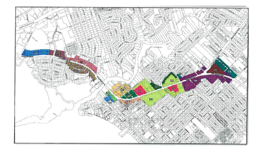
Coleman Boulevard Development Standards Table | |||||
Area | Maximum Building Height Allowed1 | Front Setback or Build-to on Coleman2 |
Front or Side Setback or Build-to on Other Streets | Rear Building Setback3 | Internal Side and Rear (Non-street) Buffers4 |
Coleman Boulevard Development Standards Table | |||||
Area | Maximum Building Height Allowed1 | Front Setback or Build-to on Coleman2 |
Front or Side Setback or Build-to on Other Streets | Rear Building Setback3 | Internal Side and Rear (Non-street) Buffers4 |
A1 | 45 ft. | 20-30 ft. BT | 20 ft. SB | 5 ft. | 5 ft. |
A2 | 45 ft. | 20-30 ft. BT | 20-30 ft. BT | 5 ft. | 5 ft. |
B1 | 45 ft. | 20-30 ft. BT | 20 ft. SB | 10 ft. | 5 ft. |
B2a - Broadway Loop | 45/55 ft.8 | 20-30 ft. BT | 10-20 ft. BT | 10 ft. | 5 ft. |
B2b - Broadway Perimeter | 45 ft. | 20-30 ft. BT | 10-20 ft. BT | 10 ft. | 5 ft. |
C1 | 45 ft. | 20-30 ft. BT | 20 ft. SB5 | 5 ft. | 5 ft. |
C2 | 45 ft. | 20-30 ft. BT | 20 ft. SB6 | 5 ft. | 5 ft. |
C3 | 45 ft. | N/A | 20 ft. SB | 5 ft. | 5 ft. |
C4 | 45 ft. | N/A | 20 ft. SB | 5 ft. | 5 ft. |
C5 | 45 ft. | 20-30 ft. BT | 20-30 ft. BT | 5 ft. | 5 ft. |
C6 | 45 ft. | 20-30 ft. BT | 20-30 ft. BT | 5 ft. | 5 ft. |
D1 - The Boulevard | 45 ft. | 20-30 ft. BT | 10-20 ft. BT | N/A | 5 ft. |
D2 - Moultrie Plaza | 45 ft./55 ft.7 | 20-30 ft. BT | 10-20 ft BT | N/A | 5 ft. |
D2 | 45 ft. | 20-30 ft. BT | 10 ft. SB | 10 ft. | 5 ft. |
D3 | 45 ft. | 20-30 ft. BT | 20 ft. SB | 10 ft. | 5 ft. |
E1 | 45 ft. | N/A | 10 ft. SB | 5 ft. | 5 ft. |
E2 | 45 ft. | 20-30 ft. BT | 20 ft. SB | 10 ft. | 5 ft. |
E3 | 45 ft./55 ft.7 | 20-30 ft. BT | 10-20 ft. BT | N/A | 5 ft. |
1 In all cases, the maximum height for buildings in the CB-OD that are located within 50 feet of an abutting residential property line, or an abutting street right-of-way adjoining residential property; provided such residential property is located outside of the CB-OD, shall be 40 feet, measured from grade to roof ridge, and further provided that no such building shall exceed a maximum of three stories. | |||||
2 Build-to lines are measured from back of curb to face of building; if no curb is present, measure from edge of pavement. Awnings and canopies are not included. Setbacks are measured from the right-of-way line. | |||||
3 In all cases where rear or side property lines abut residential properties lying outside of the CB-OD, a minimum 15-foot setback is required, within which a minimum 10-foot type "C" bufferyard with an F3 fence is also required. | |||||
4 Common wall construction to adjacent properties spanning property lines may be utilized in accordance with applicable building and fire code requirements. Buffers are not required where interconnectivity between parcels is provided or shown on the plan for future connection, or when common wall construction to adjacent properties spanning property lines is utilized. Where interconnectivity or common wall construction is not provided, a minimum type "A" bufferyard plant unit material is required. | |||||
5 The 20 ft. setback applies to all side streets except Mill Street, where a 20-30 ft. build-to is required. |
6 The 20 ft. setback applies to all side streets except Simmons Street, where a 20-30 ft. build-to is required. |
7 The 45 ft. building height limit shall apply to those portions of a building immediately located along a street frontage. Portions of a building between 45 feet and 55 feet must be set back from the right-of-way, at a distance to be determined through the design review process. |
8 • The height of all buildings in this subarea will be measured from the elevation of the top of the curb on Coleman Boulevard. • The 45-foot building height limit shall apply to the facade of any building located along and parallel to Coleman Boulevard or a facade on those portions of Broadway Street which are perpendicular to Coleman Boulevard. • To achieve the maximum allowed height of 55 feet, such portions of a building above the height of perimeter facades must be set back away from a street and be contained within a building envelope established using a 1:4 slope beginning at the top of the facade on Coleman Boulevard or a facade on those portions of Broadway Street which are perpendicular to Coleman Boulevard. No step- back in height is required for facades which front on the remainder of Broadway Street. |
2. Bufferyards and plantings.
a. However, three canopy trees of a minimum-four-inch caliper shall be required for each 100 linear feet of road frontage, using species such as Southern Red Oak, Live Oak, Willow Oak, Elm varieties and American Beech. Such tree types to be consistent with each block and evenly spaced, with exceptions made for curb cuts, utilities, and other obstructions. On side streets, the required street trees shall be located in an area behind the sidewalk.
i. Internal side and rear (non-street frontage) bufferyards shall be provided in accordance with the requirements of the Development Guidelines Table and map.
ii. Sabal palmettos shall be planted in the public right-of-way adjacent to lots on Coleman Boulevard, at approximately 30 feet on center. Additional low shrub or groundcover plantings, including grass, may be required between the Sabal palmettos in the verge.
iii. Parking lot islands, which must include canopy trees of four-inch caliper or larger, of a species approved during the design review process, must be provided at a minimum of every 12 spaces when adjacent to rear or side property lines, and internal parking lot islands either shall be provided at a minimum of every 12 spaces or only at the end of parking rows.
b. Sidewalks and landscaping.
i. There shall be a public sidewalk, either within the right-of-way or within a pedestrian easement on private property, on both sides of all streets within Coleman Boulevard, a minimum of five feet wide on side streets and internal access roads, and a minimum of eight feet wide on boulevard streets.
ii. On boulevard streets, these walks shall typically be separated from traffic by a grassed verge, which shall be a minimum of three feet wide, measured from the back of curb, and planted with palmettos at approximately 30 feet on center; provided, however, that where on-street parking is utilized, the palmettos may be planted in openings of three feet by three feet, with eight-foot-wide sidewalks serving the parallel parking areas. See Figures 7, 8 and 9.
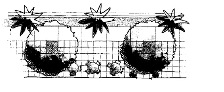
Figure 7. Location of Palmetto Street Trees.
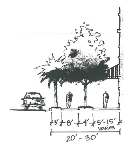
Figure 8. Street Tree Locations.
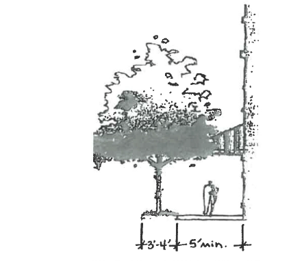
Figure 9. Side Street Detail.
3. Lot frontage/pocket parks.
a. On Coleman Boulevard, between the intersection of Lansing Drive and the intersection of Chuck Dawley Boulevard, the minimum building frontage on properties of less than 100 feet shall be 100% of its frontage, except for adequate allowance for one curb cut. The total required building frontage may be accomplished through a phased development plan.
b. For properties with more than 100 feet of frontage on the boulevards, a minimum of 70% building frontage shall be required. The total required building frontage may be accomplished through a phased development plan.
c. Pocket parks, plazas, and other civic open spaces that are integrated into the overall design of a project shall count for a maximum of 20% of the required building frontage.
d. The minimum allowable size of a pocket park or other suitable civic open space shall be 12 feet of frontage and 300 square feet of overall area.
(e) Johnnie Dodds Boulevard.
1. Bufferyards.
b. Front yard. Street trees are required. Three canopy trees of a minimum-four- inch caliper shall be required for each 100 linear feet of road frontage, using species such as Southern Red Oak, Live Oak, Willow Oak, Elm varieties, and American Beech. Such tree types to be consistent with each block and evenly spaced, with exceptions made for curb cuts, utilities, and other obstructions.
c. Side and rear yards. In general, bufferyard requirements on individual parcels are specified in § 156.201; however, contingent upon approval through the Design Review Process, development utilizing an integrated site plan involving multiple parcels may forgo side and rear bufferyards along parcel lines, except when commercial uses abut residential uses lying outside the district boundaries. In the latter case, a minimum ten-foot, Type "C" bufferyard, with an F3 fence, is required in all instances. This buffer may overlap with the required side and/or rear yard setback. In addition, buffers are not required where common wall construction to adjacent properties spanning property lines is utilized in accordance with applicable building and fire code requirements.
d. Pedestrian trails. Pedestrian trails/access/open space/parks. A key component of the JDB Area is the provision of an integrated pedestrian and bicycle access plan through sidewalks and trails. This system is graphically depicted in an illustrative manner in Figure 17 below. Dedication of easements and construction for sidewalks and pedestrian trails on development parcels may be required in the approval process to implement this pedestrian and bicycle access system. In addition to the pedestrian trail system, areas suitable for open space and parks are illustrated in the following Figure 17.
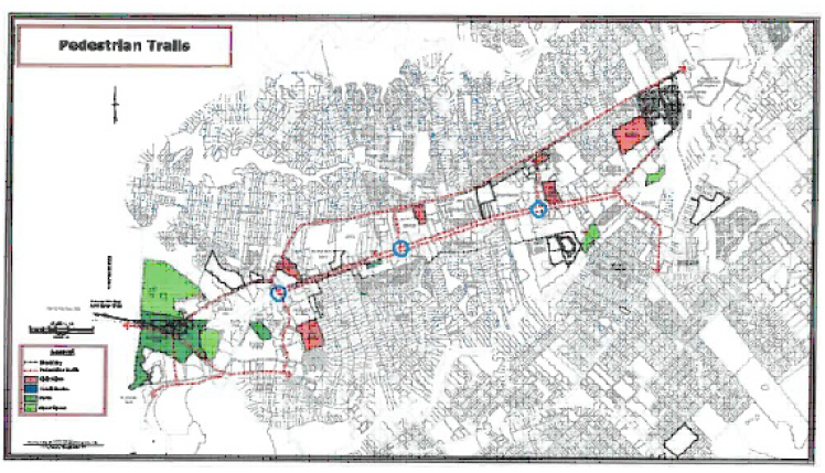
Figure 17.
(f) Chuck Dawley Boulevard.
1. Bufferyards.
a. Front yard.
i. For buildings fronting on Chuck Dawley Boulevard or side streets, no understory or shrub plantings are required.
ii. However, three canopy trees of a minimum-four-inch caliper shall be required for each 100 linear feet of road frontage, using species such as Southern Red Oak, Live Oak, Willow Oak, Elm varieties, and American Beech. Such tree types to be consistent with each block and evenly spaced, with exceptions made for curb cuts, utilities, and other obstructions.
b. Side and rear yards. In general, bufferyard requirements on individual parcels are specified in § 156.201. However, contingent upon approval through the design review process, development utilizing an integrated site plan involving multiple parcels may forgo side and rear bufferyards along parcel lines, except when commercial uses abut residential uses lying outside the district boundaries. In the latter case, a minimum ten-foot, type "C" bufferyard, with an F3 fence, is required in all instances. This buffer may overlap with the required side and/or rear yard setback. In addition, buffers are not required where common wall construction to adjacent properties spanning property lines is utilized in accordance with applicable building and fire code requirements.
(J) Applicable to all buffer areas.
(1) All required plant material must be accommodated within the buffer; except as provided elsewhere herein.
(2) Drainage swales may be placed in the buffer only when trees are not endangered, and only when the swale meanders through the buffer in an unobtrusive manner. These swales may not be designed to hold water, only to direct water. Therefore, ponds shall not be allowed.
(3) With the exception of permitted free- standing signs or utility ground cabinets, structures may not be placed within the buffer. Such utility ground cabinets are discouraged from being placed in a buffer adjacent to a public right-of-way.
(4)
Components of the Mount Pleasant Way as indicated by its Master Plan may be placed within required buffers in a sensitive manner. These intrusions shall be reviewed by staff (and DRB if applicable) during the design process to minimize intrusions, protect the quality of the buffer, and minimize impacts on protected trees. Every reasonable effort shall be made to accommodate displaced plantings elsewhere within the remaining buffer.
(5) Where incentives are provided within the latest edition of “The Environmental Guidelines for Land Development,” alternative buffer width and uses shall be allowed.
(6) Aerial transmission power line/buffer impacts.
(a) Where protected trees are mutually considered danger trees, as defined in § 156.221 of this chapter, by the power provider and the Zoning Administrator, their removal request shall be submitted in plan form and may be granted, with replacement being required, as outlined in the Tree Protection Ordinance, to be planted on the site of the requested removal. Where buffer configuration, aerial power line conditions or other circumstances or conditions do not permit canopy tree replacement, the largest size tree or tall shrubs may be permitted, with replacement calculations based upon nursery standards or an equivalent donation made to the Tree Bank as determined by Town Council.
(b) Where protected trees are mutually considered danger trees, as defined in § 156.221 of this chapter, by the power provider and the Zoning Administrator, such trees may be pruned only in accordance with town standards and with the specifications provided in the latest version of ANSI A300. ANSI A300 Standards for Tree Care Operations specifies acceptable alternatives to topping that may be considered.
(c) Where power line maintenance operations cause violation of the Tree Protection Ordinance by means such as excessive pruning, based upon pruning standards referenced in § 156.227, the tree may be considered damaged and require removal and replacement. Damage to buffer vegetation as a part of any maintenance activity shall require replacement in kind.
(d) Where taller maturing species of trees exist directly under the power lines, pruning practice would otherwise require a tree to be topped, resulting in a standing stub without lateral limbs, they may be removed with Zoning Administrator approval, and may require replacement with more power line- compatible species.
(e) Regular line clearance pruning may be permitted on cyclical events, provided that pruning is the minimum legally required.
(f) No portions of a buffer may be maintained by clear cutting or herbicide applications.
(g) Where existing aerial lines are to be placed underground, locations for ground cabinets should first be sought outside of the buffer. Where other options do not exist, minimal portions of the buffer may be cleared to allow for the setting of ground cabinets, with Zoning Administrator approval of the plans, and replanting required around the cabinets to screen them and best reestablish all vegetative levels of the buffer.
(7) Where road widening or other road improvements impact existing bufferyards, a buffer width reduction may occur only when a full buffer width cannot be accommodated with site adjustments. Where a full bufferyard width cannot be provided through site adjustments but some additional width can be accommodated, the width shall be increased to the maximum extent possible. Required plant quantities, based upon the pre-road improvement buffer width within impacted buffers, may only be reduced to the extent that plantings cannot fit within the final approved bufferyard width. The potential to have plantings within the right-of-way may be considered where plantings on private property cannot be accommodated.
(K) Protected vegetation. All vegetation required by the provisions of this division is protected and requires prior approval for the alteration of bufferyard width or removal of bufferyard vegetation. Mitigation for removal is required by replacement or through donation to the town's Tree Bank in applicable situations.
('81 Code, §151.99) (Ord. passed 8-13-79; Am. Ord. passed 4-9-84; Am. Ord. passed 1-10-89; Am. Ord. passed 6-9-92; Am. Ord. 99012, passed 4-21-99; Am. Ord. 99069, passed 1-11-00; Am. Ord. 00052, passed 9-12-00; Am. Ord. 02024, passed 6-11-02; Am. Ord. 05003, passed 2-8-05; Am. Ord. 07071, passed 11-13-07; Am. Ord. 09079, passed 12-9-09; Am. Ord. 09088, passed 1-13-10; Am. Ord. 10082, passed 1-11-11; Am. Ord. 11007, passed 2-8-11; Am. Ord. 12005, passed 2-14-12; Am. Ord. 12064, passed 10-9-12; Am. Ord. 14047, passed 8-12-14; Am. Ord. 16084, passed 10-11-16; Am. Ord. 18076, passed 11-13-18; Am. Ord. 19027, passed 5-14-19; Am. Ord. 20005, passed 2-19-20; Am. Ord. 20041, passed 8-14-20; Am. Ord. 21042, passed 5-11-21; Am. Ord. 21067, passed 10-12-21; Am. Ord. 22004, passed 2-8-22; Am. Ord. 22019, passed 3-8-22; Am. Ord. 23006, passed 2-14-23)