
Golden eagles, like many other raptors, know how to take the path of least resistance. When they spread their wings and take to the skies, they typically look for updrafts (upward pushes of air) which enable them to sustain flight longer by soaring and conserving energy. However, the locations and conditions that enable this kind of flight are also favorable for wind energy generation, increasing the potential of collisions between wind turbines and eagles and other similar animals.
While wind energy has many environmental benefits and its expansion is critical to achieving the nation’s clean energy production goals, it must be developed in a way that prioritizes coexistence with wildlife. Eagles are particularly important in this context because of their conservation status and protection under law in the United States.
Helping developers and operators visualize how these magnificent creatures might fly around wind power plants is key to help wind turbines and eagles share space in a safer way. Now, we are one step closer to doing just that.
A Change in the Wind
A new software—the Stochastic Soaring Raptor Simulator (SSRS)—developed at the National Renewable Energy Laboratory (NREL), with support from the U.S. Department of Energy’s Wind Energy Technologies Office, endeavors to predict the most likely long-distance flight paths of individual golden eagles as they ride updrafts.
An SSRS user can choose a site, then either provide the wind conditions or ask for a specific date and time. The model, which is publicly accessible on GitHub, will then simulate the likely routes golden eagles would take as they travel through the site.
The SSRS goes beyond the capabilities of previous agent-based models (with raptors being the “agents”) by incorporating information about individual sites of interest, accounting for uncertainties in atmospheric conditions, and predicting raptor decision making.
The user selects a region of interest, which could be anywhere in the United States, and the model will import terrain features, atmospheric conditions, and turbine locations from publicly available data sources. The model then calculates where favorable updrafts might occur. Finally, the moving parts get added: virtual migrating golden eagles, starting at randomly or uniformly spaced points. SRSS simulates their flight paths, which are then combined to provide a cumulative map that shows the eagles’ possible location at any given time.
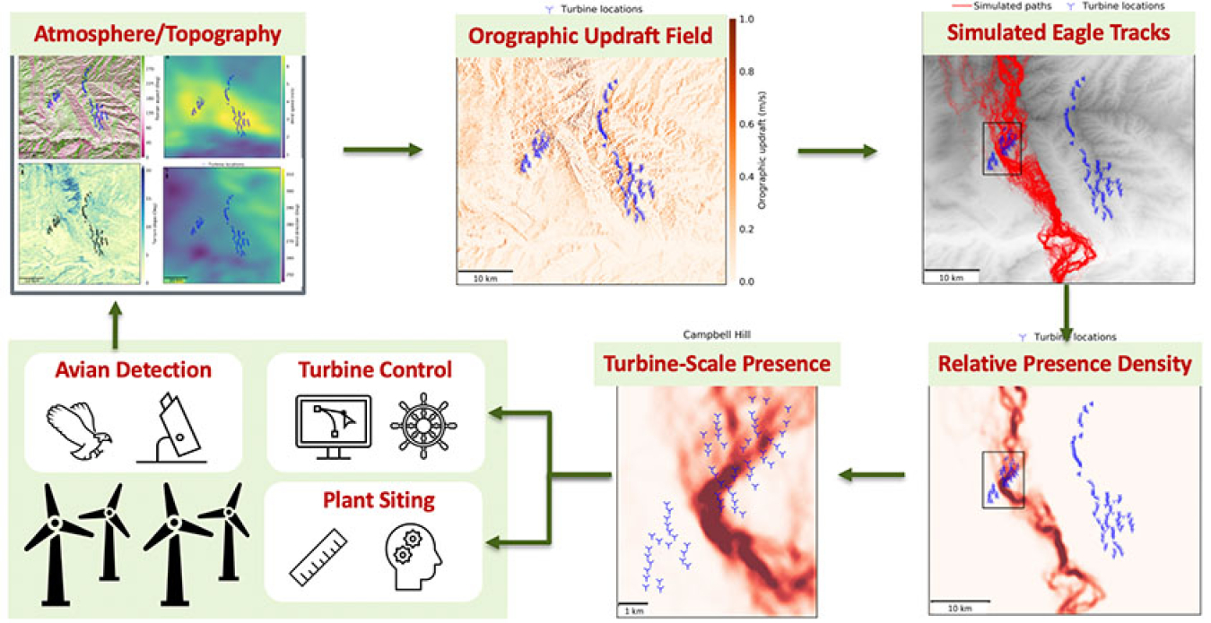
The workflow of the Stochastic Soaring Raptor Simulator, with example maps illustrating the predicted overlap between likely golden eagle flight paths and wind turbine placements.
“A golden eagle’s goal to minimize its energy expenditure will affect its decision making. The model uses that principle to generate a map of probable paths the eagle might take,” said Rimple Sandhu, who is a postdoctoral researcher at NREL and the lead author on the article published in Ecological Modelling.
These maps of probable paths—called relative presence maps—highlight potential interactions, if any, where thousands of flight paths may coincide with wind turbine locations. This helps users evaluate turbine placement options that might be less dangerous for the birds.
Flying High
The simulator is uniquely designed to investigate variations in atmospheric conditions and eagle behavior throughout the seasons as well as differences throughout day and night.
The team, which also included collaborators at Western EcoSystems Technology, Inc., the U.S. Geological Survey, Conservation Science Global, West Virginia University, and Lafayette College considered example cases at both seasonal and hourly scales and compared simulated tracks to a year of real eagle flight paths from GPS-tagged birds taken near three wind power plants in Wyoming. Although the model is two-dimensional and the observed data show vertical changes, the overlap was promising. For example, the presence maps for migrating golden eagles clearly identified separate routes for southern migration and northern migration near a particular power plant.
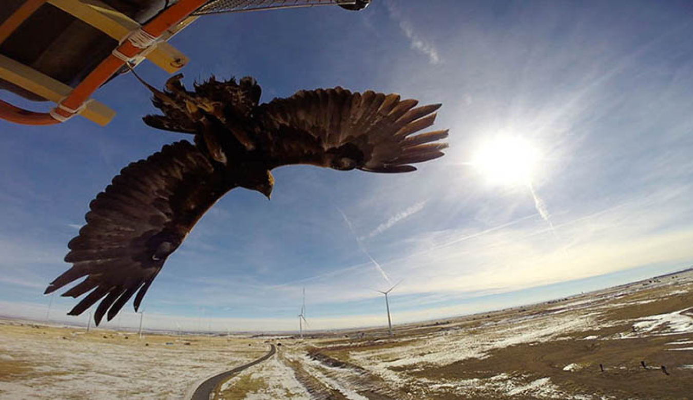
A new simulator, developed by NREL, allows users to model the movements of soaring raptors, such as golden eagles and bald eagles, which prefer to ride updrafts at the same altitudes as wind turbine blades. The model’s predictions at specific locations in the United States, times of year, and wind conditions could help reduce potential collision risks of wildlife with wind turbines.
“Observations indicate that golden eagles tend to fly at higher altitudes in summer than in spring and fall. These observations coincide with the greater strength and density of thermal updrafts during summer time, which eagles utilize for high-altitude soaring,” says Charles Tripp, one of the principal investigators on the study and a machine learning researcher at NREL. “Understanding the link between atmospheric conditions and flight patterns at the turbine scale can inform a wind farm operator's curtailment measures. The better we understand eagle flight patterns, the more we can optimize curtailment measures.”
With the results from the SRSS, wind power plant operators could dynamically alter turbine activity based on local conditions to avoid wildlife-turbine collisions in real time. For example, operators could sharpen their mitigation efforts to certain higher-risk times of the year, deploying cameras or monitors during seasons when SRSS suggests eagles might be more active in the area and shutting down turbines when eagles are detected. And wind power plant developers could consider siting (meaning placing) turbines in lower-risk locations to begin with.
Planning for Convocations of Eagles and Turbines
Although golden eagles are often thought of as solitary birds, they can also travel in groups called “convocations.” To plan for this, the program can also generate a density, or heat, map displaying the relative spacing of the eagles at a resolution of 50 meters (about the length of an average wind turbine blade—equivalent to the width of a U.S. football field). These maps are one source of information that can help wind power plant developers determine the best layout for a field of wind turbines.
Although this model is specific to golden eagles, the authors are confident that their model can be adapted to other soaring birds or regions of interest to help install wind turbines in less risky areas and operate in ways that reduce risks to raptors.
At a recent online workshop, researchers from NREL presented new improvements to eagle models and discussed next steps with stakeholders from the wind energy industry, state and federal agencies, nongovernmental organizations, and academia.
“Considering any negative impact of wind plants on wildlife requires looking at it from all angles,” Sandhu said. “With the help of a bird’s-eye view, wind energy can soar as high as the eagles can.”
Article first published by NREL.
Subscribe to the WETO e-newsletter to stay informed on the latest wind energy news, events, publications, and updates.